Geocoding in the heart of Central Florida: EMS route round ups
This weeks lab was pretty fun! I had a blast geocoding addresses of the various Fire/EMS stations in Lake County, FL. What I found odd about the process is the matching addresses part. It was strange that several of the addresses listed in the database were matched to street/highway locations which were in the middle of nowhere.
What I found fun about the Geocoding part for searaching for the locations on Google Maps and Bing Maps. It's funny that Google maps had some completely different street numbers on the same roads that Bing Maps had. I much prefer the graphics and layout of Google Maps!
It's also cool that we can essentially tailor create our driving routes. We can choose which way is the fastest route or one that gets location drop offs in the most inconvenient locations first, so that the easy ones (the best) can wait for last.
Overall I really enjoyed this lab! There's plenty more to learn about incorporating more datasets in maps, configuring driving directions in a more fine-tuned manor, and obviously more skill from more practice!
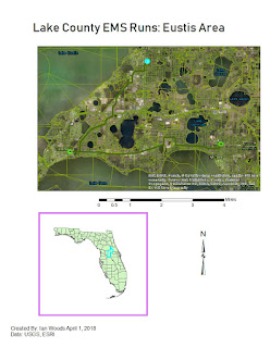
Here is the below map I created. I have used the cntbnd file for showing where in Florida Lake County resides. It's definitely a mixed bag. Located just northwest of Orange Co., the Orlando area, Lake County is partially urban and mostly rural. The cities and towns of Lake County are fairly small for the most part. As I type this, it occurred to me that Lake County has a fairly large elderly population because of the well known retirement community of The Villages- just another reason to have plenty of Emergency Services facilities available. They may need many more in coming years!


Comments
Post a Comment