Posts

Showing posts from January, 2018

Escambia County and the University of West Florida
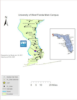
Image
For anyone not sure of the location of the University of West Florida, I hope this following map will help: In this map which I created in ArcGIS, you can easily see that the University of West Florida resides in Escambia County, which is the westernmost county in the Florida Panhandle and state of Florida. Escambia County contains various little towns and cities immediately surrounding the metropolitan Pensacola area. In my map is placed a handy legend used to identify cities, rivers, and roads. The university of West Florida can easily been seen with the  bright yellow star just to the north of Pensacola.

My First GIS map!

Image
In a lot of courses I've taken in college, the thought of an assignment needing to be completed sounded dreadful. But in my GIS Introductory course I had the pleasure of creating my own map! Seen here are the various and many countries of the world. In each country placed on this world map is a Legend showing the approximate Populations of various larger cities in each of the countries. It is really cool to sit back and look at what you can do in ARCMaps! Those thousands of little black dots simply represent where thousands and millions of people live. It's interesting to look at the shapes of each country within each continent and realizing just how vast the topography is where these millions of cites and people live! I sure enjoyed creating this map! I couldn't have done it without the help of ARCmaps through ESRI. I also give a big thanks to the USGS for their tremendous amounts of data!

Introduction

Image
Hi, I'm Ian Woods. I am excited to learn about GIS. Admittedly this subject matter is somewhat new to me, but I am eager to learn. I learned about GIS only about 2-3 years ago and I had to research a little bit to realize that this kind of subject was right up my alley of interest. At a young age I used to enjoy drawing out maps of various different geographical areas: My home town, crude-looking maps of the United States (with various interstate highways which run across each state), and maps of Florida. I have always enjoyed drawing/ making maps. I also have a huge interest in weather which has great need of GIS data to generate forecast maps. And recently I have gained an interest in retail shopping centers in the realms of their location, attractiveness, ease of access, and design. I'm really full of a bundle of interests and I feel the learning about GIS in this course will help me tremendously in securing a career in a  GIS type of job. I am looking forward to reading